Wildfires of the future: new participatory approaches based on territorial planning
Professor, Universidad de Extremadura
Director, MOSAICO Initiative(se abrirá nueva ventana)
Several recent scientific reviews dealing with the issue of wildfires have called attention to the fact that the problem is growing more severe, as discussed in the latest UN report(A new window will open) (2022) 1United Nations Environment Programme (2022). Spreading like Wildfire – The Rising Threat of Extraordinary Landscape Fires. A UNEP Rapid Response Assessment. Nairobi.. Weather conditions associated with wildfires are becoming more frequent in most regions around the globe as a consequence of climate change. Even by the most conservative forecasts, wildfires are expected to increase significantly worldwide, with a concomitant rise in the frequency of extreme fires. These conditions have already had an impact on certain fires on the Iberian Peninsula, where the decline in rural communities over the years has turned long-standing accumulation of vegetation that acts as fuel into a particularly salient factor.
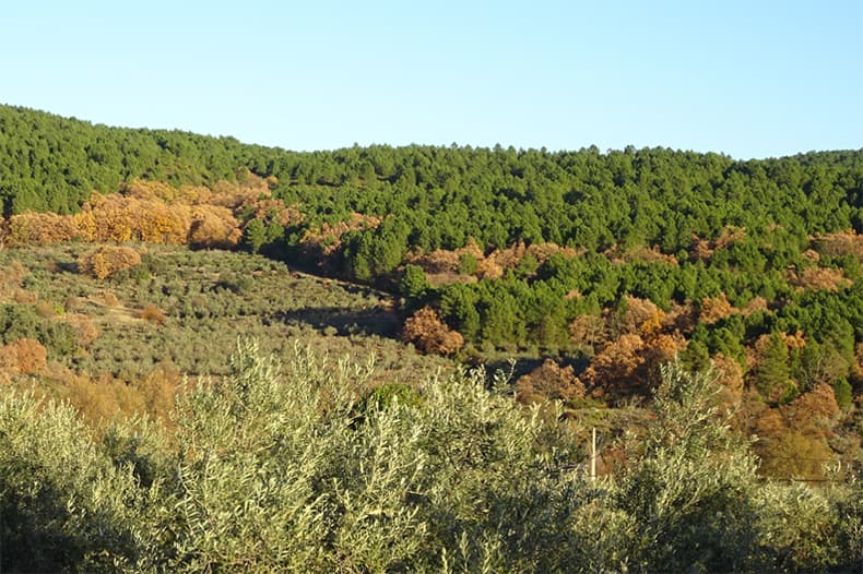
Wildfires are commonplace in the countries of the Mediterranean region, and the 2022 fire season in southwest Europe (Portugal, Spain, and France) was extreme. The burned area was 52 times greater than the 2001-2021 median in some regions, and large wildfires (more than 500 ha, abbreviated LWFs) began breaking out in June, ahead of the habitual wildfire season. A few large wildfires accounted for 82% of the burned area. Situations of this kind arise only under extreme weather conditions in areas that have not been managed for decades (Figure 1).

Figure 1. View of agricultural land in the Sierra de Gata, Cáceres being overgrown by forest.
Source: F. Pulido.
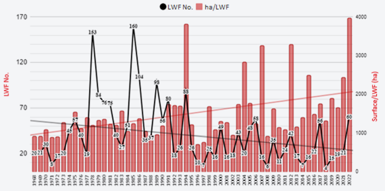
Paradoxically, the number of wildfires and the total burned area have been declining in southern Europe in recent decades. In Spain both the number of LWFs and their numerical share of fires as a whole have also undergone a clear decrease (Figure 2). However, the proportion of burned area produced by LWFs has tended to rise, meaning that just a few fires are capable of accounting for a large part of the burned area. These fires have devastating economic and environmental effects and in most cases represent humanitarian catastrophes. That is, wildfires often outstrip the capacity of professional fire-fighting services to suppress them and overwhelm costly conventional fire prevention infrastructure.

Figure 2. Number of large wildfires (over 500 ha) and burned area in Spain {data source: Ministry for Ecological Transition and the Demographic Challenge (MITECO)}.
Paradigm shift: towards adapted landscapes
In this scheme of things, more and more international scientific voices are being raised to call for a new approach based on greater expenditures on fire prevention measures, not necessarily at the expense of spending on the means of suppression but rather coordinated policies to regulate land use so as to promote preventive action by livestock raising, crop farming, and forest management in high-risk areas. The aim is thus gradually to create adapted landscapes where wildfires may occur but will not grow to catastrophic size.
The concept of Fire-Smart Territories (FSTs) has recently been put forward as territories that use a shared management model in which empowered communities with high levels of knowledge and skills are able to take decisions and manage wildfire risk to keep the risk at very low levels through social and economic activities capable not only of containing (and ultimately eliminating) wildfire hazards but also of promoting the beneficial use of fire (Tedim et al. 2016 2Tedim, F., Leone, V., & Xanthopoulos, G. (2016). A wildfire risk management concept based on a social-ecological approach in the European Union: Fire Smart Territory. International Journal of Disaster Risk Reduction, 18, 138-153.). The linchpins of this concept are: (1) the social basis of the solution; 2) interaction between institutions and local communities; (3) overlap of multiple coexisting land uses to bring about fuel reduction; and (4) communication among agents, including regulatory changes and incentives as a basis for adaptive management of the solution. A more operational definition of an FST that has been put into practice by the Mosaico Initiative in Extremadura (https://mosaico-land.com(A new window will open)) would be a territory where a combination of indirect fire prevention measures based on forestry, agricultural, and livestock-farming practices carried out by local stakeholders together with direct prevention measures (fuel management by government services) is jointly implemented.
Fuel in adapted landscapes can be reduced both through strategic direct interventions funded by government agencies and through non-strategic indirect interventions (e.g., grazing, crop farming, and wood harvesting) whose expected economic benefits justify expenditures by local land managers, with or without public support. The main advantages of direct intervention are related to their strategic location in respect of prospective fire behaviour and their mostly immediate implementation once they have been officially formulated. However, the high cost and short usefulness (about three years in Mediterranean vegetation) of these fuel management actions usually prevent them from being applied over large tracts. By contrast, indirect interventions implemented by local land managers are long-lasting and can cover large areas at no or reduced cost. They also generate economic returns and promote stakeholder engagement in the territory. Unlike targeted measures, indirect interventions may have a diffuse effect spread over larger areas, which can be effective in reducing wildfire size and severity.
Resilient landscapes in historic wildfires
Agroforestry landscapes are less affected by large and severe wildfire events than forests, shrublands, or grasslands, evidencing their large-scale potential to reduce fire hazard and increase fire suppression capabilities. Large, severe fires have been closely linked to rural abandonment since the mid-twentieth century, a trend that has brought about extremely rapid transition of traditional farmlands to forested landscapes. The loss of agroforestry mosaics ends up causing forest patches to merge, thereby increasing fuel continuity, which can drive many wildfires to levels that exceed suppression capabilities.
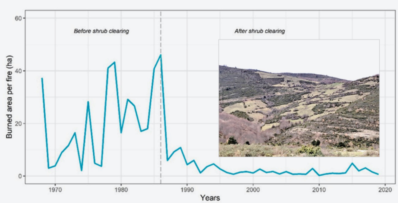
The effect of mosaic or variegated rural landscapes on wildfires has been implicitly documented on a number of occasions. Simulations projecting different rates of abandonment of rural areas evidence the resulting shift towards larger wildfires. One long-term project based on clearing shrubland followed by cattle grazing resulted in an 83% decrease in average wildfire size (Figure 3, Lasanta et al.(A new window will open) 2022 3Lasanta, T., Cortijos-López, M., Errea, M. P., Khorchani, M., & Nadal-Romero, E. (2022). An environmental management experience to control wildfires in the mid-mountain Mediterranean area: Shrub clearing to generate mosaic landscapes. Land Use Policy, 118, 106147.).

Figure 3. Decrease in the mean fire surface area achieved by shrubland clearing followed by grazing in La Rioja (Spain).
Source: Lasanta et al. 2022.
Optimising wildfire-adapted landscape design
The need to design agroforestry mosaics capable of preventing fires has recently been advocated in Spain (Madrigal et al. 2019(A new window will open) 4Madrigal, J., Romero-Vivó, M., and Rodríguez y Silva, F. (eds.) (2019). Definición y recomendaciones técnicas en el diseño de Puntos Estratégicos de Gestión [Specifications and technical recommendations for Strategic Management Point design]. «Decálogo de Valencia» para la defensa integrada frente a los incendios en la gestión del mosaico agroforestal [The Valencia «Ten-point Scheme» for agroforestry mosaic management for integrated wildfire protection]. Sociedad Española de Ciencias Forestales. Valencia.). The authors of that article proposed the following definition of “agroforestry mosaic”: a heterogeneous restructuring of a mainly forested landscape achieved by using it for farming, livestock-raising, or forestry purposes, thereby significantly altering fuelscapes to keep fires from spreading and/or to make it easier for operations by fire-fighting services. Placing structures with little or no combustibility (e.g., tree crops, ploughed fields, or rangeland) in the path of a fire slows its spread, keeps areas with substantial amounts of fuel (unreached forests and shrubland) from burning, and can even make the work of fire-fighting services easier.
In this context the term “productive firebreaks” (PFs) has recently been coined to designate territories that are in permanent use and hence have low fuel loads, enabling them both to act as passive firebreaks and to provide access for fire-fighting services. PFs can be created through the agency of forest harvesting, farming, grazing, or combinations of mixed agroforestry use (Pulido 2021(A new window will open) 5Pulido, F. 2021. Towards smart territories tackling forest fires Ciudades 24, 65-78.). However, planning that takes prospective fire behaviour into account is needed to maximise the deterrent effects of PFs and enable them to be regarded as fire-prevention infrastructure.
While the approach itself would appear to be simple, putting it into practice comes up against constraints rooted in the disconnect between forest, livestock, and farming policies that are designed without regard to any territorial planning strategies or fire-prevention requirements. Therefore, actual implementation depends on the amenability of local landscape managers (farmers, ranchers, forestry engineers), who, furthermore, play a key role in lowering future maintenance costs by putting PFs to profitable use. As a result, building PF infrastructures requires a prior understanding of the underlying social networks involved and the public and private cost-benefit balance derived from implementation. The experience in La Rioja showed the approach to be viable and paves the way for other forms of preventive productive activities.
One major advantage is that PFs can be created by many different types of productive activity capable of reducing the fuel load, such as growing both herbaceous and woody crops, grazing different animals, and harvesting timber or biomass through forest clearing or resin tapping activities. What is more, since by maintaining the PFs local participants can obtain extra income from public and/or private sources, they can also serve as permanent caretakers for infrastructure they do not want to see destroyed by fire. Lastly, the surface area that can be given over to PFs is clearly both much greater than conventional infrastructure and less costly to maintain, which makes them a prospective tool that holds out great socioeconomic and environmental interest.
The current state of knowledge of fire burn patterns over different types of vegetation formations and terrain enables us to predict the strategic areas where wildfires can be stopped either actively (through fire suppression) or passively (through insufficient fuel). Representative of the former type of area are Strategic Management Points or Zones (SMPs or SMZs; Figure 4) (Madrigal et al. 2019), which can be used to aid in fire suppression and to that end must be readily accessible and clear of vegetation. The latter type of area only needs to have a low fuel load, achievable through the preventive use of farming, grazing, or forest clearing or PFs.
SMPs can help with suppression, but for a variety of reasons an adapted landscape also needs to include PFs. The first reason is that wildfire size, the cost of suppression, and subsequent impacts all decrease in proportion to the amount of land that is clear of fuel. Furthermore, the greater the share of strategic landscapes used for production, the lower the maintenance costs for the system as a whole. On top of this, productive landscapes serve as a deterrent, and landscape managers look after them against miscreants. Lastly, recognising the preventive benefits of PFs inherently fosters public-private partnerships and shared responsibility. Keeping all the above considerations in mind, for implementation designing adapted/smart landscapes to protect against wildfires has to seek a balance between PFs and SMPs suitable for the territory concerned and the resources available. PFs are low in cost and long-lasting, whereas SMPs entail high implementation and maintenance costs but offer less uncertainty as to their outcomes. Figure 4 portrays most types of public-private measures that can be used in rural areas in the Mediterranean region.
![Figure 4. Types of public-private measures that can be employed in rural areas in the Mediterranean region. Source: Generalitat Valenciana [Regional Government of Valencia] 2012. Instrucciones para el diseño de áreas cortafuegos [Instructions for firebreak design]. Valencia. Figure 4. Types of public-private measures that can be employed in rural areas in the Mediterranean region. Source: Generalitat Valenciana [Regional Government of Valencia] 2012. Instrucciones para el diseño de áreas cortafuegos [Instructions for firebreak design]. Valencia.](/almacen/numero-21/ENG/Wildfires-of-the-future_04.jpg)
Figure 4. Types of public-private measures that can be employed in rural areas in the Mediterranean region.
Source: Generalitat Valenciana [Regional Government of Valencia] 2012. Instrucciones para el diseño de áreas cortafuegos [Instructions for firebreak design]. Valencia.
Public policies and adapted landscape planning
Implementation of PFs as a basic operational unit for landscapes adapted to the new pattern of wildfires could be fomented by support policies expressly designed to promote their preventive side that make use of mechanisms provided in the Common Agricultural Policy (CAP). Unfortunately, for the time being territorial policies do not recognise the cost avoidance achieved by agroforestry activities, so as a rule there are no public means of paying for those benefits. Furthermore, current legislation restricts changing over from forestry use to other, less hazardous uses. In addition to the preceding limitations, there are others attaching to the appropriateness of exploiting protected areas, which further restricts options for using territories preventively and ultimately contributes to the continued presence of forestry mass subject to little management. The evident geographical mismatch between the allocation of EU funds for rural development and wildfire incidence has already been studied for Italy. At the same time, in view of the severity of the wildfire problem in 2017 and subsequent years, Portugal has begun setting up a national system of Integrated Landscape Management Areas aimed at protecting against wildfires (ILMAs). The scheme makes provision for allocating funds to specific areas where a public-private partnership has been set up for preventive territorial use.
In Spain the mountainous lands management legislation encourages the autonomous regions to designate High Wildfire Risk Areas (ZAR for the Spanish Zonas de Alto Riesgo de Incendio), but implementation and subsequent follow-up has been patchy, and in any case that scheme has not been designed to foment participation and commitment by local participants. And unlike the Portuguese ILMAs, it does not envisage any specific allocation of funds. To conclude, national, regional, and local governance programmes all have insufficiencies that prevent them from embarking on a new wildfire management scenario.